Backcountry Protected Areas of the Muskwa-Kechika Management Plan
Share Backcountry Protected Areas of the Muskwa-Kechika Management Plan on FacebookShare Backcountry Protected Areas of the Muskwa-Kechika Management Plan on TwitterShare Backcountry Protected Areas of the Muskwa-Kechika Management Plan on LinkedinEmail Backcountry Protected Areas of the Muskwa-Kechika Management Plan link
September 2024: This survey is now closed. Thank you for participating!
Share your voice! BC Parks is inviting the public’s feedback on the draft management plan for the protected areas in the Muskwa-Kechika backcountry. Read below to learn more about the management planning process, important dates, and to participate in the survey.
Background:
The Muskwa-Kechika Management Area (M-KMA) was established in 1998, with the intent to achieve a balance between economic development and conservation. The overall goal is to allow resource development to occur in appropriately zoned areas, while maintaining, in perpetuity, the:
wilderness quality,
diversity and abundance of wildlife, and
ecosystems on which wildlife depend.
To support land management, the Muskwa-Kechika Management Area Act specified the creation of an overarching management plan (completed) and five types of local strategic plans, including park management plans. Within the boundaries of the M-K MA, there are 22 provincial parks and protected areas managed by BC Parks. Two parks – Northern Rockies and Redfern-Keily Provincial Parks – already have approved management plans. The remaining parks have been grouped together into either front-country or backcountry park plans and are undergoing the management planning process.
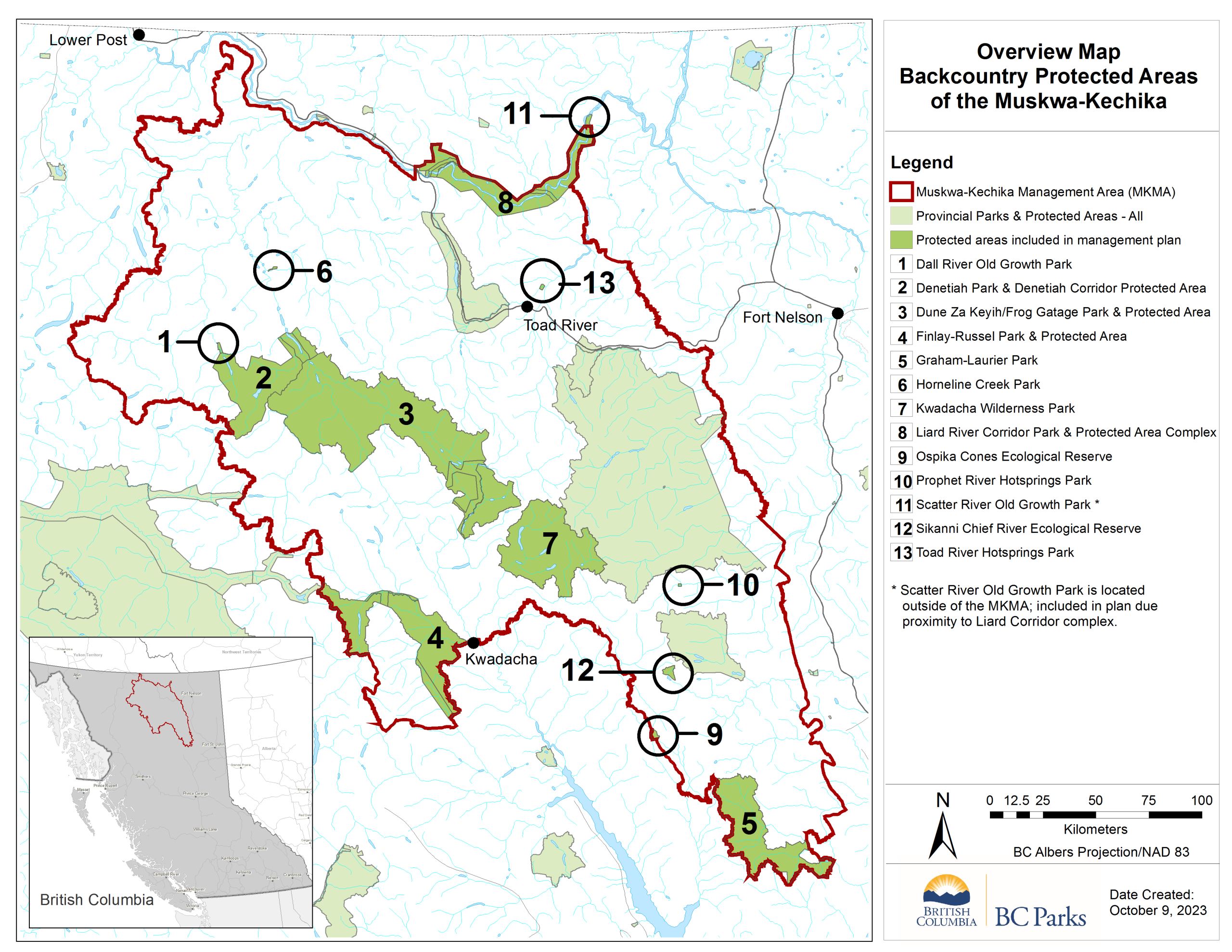
At this point the Backcountry Protected Areas of the Muskwa-Kechika: Strategic Management Plan has been drafted and is ready for public review. There are 18 individual parks and protected areas included within this plan. BC Parks has combined the protected areas together into one plan as they all contain similar conservation values, cater to similar recreational activities, are remote, and have limited access/use. The parks within this management plan include:
Dall River Old Growth Park
Denetiah Park
Denetiah Corridor Protected Area
Dune Za Keyih [a.k.a. Frog-Gataga Park]
Dune Za Keyih [a.k.a. Frog-Gataga Protected Area]
Finlay Russel Park
Finlay Russel Protected Area
Graham-Laurier Park
Horneline Creek Park
Kwadacha Wilderness Park
Liard River Corridor Park
Liard River Corridor Protected Area
Laird River West Corridor Park
Ospika Cones Ecological Reserve
Prophet River Hot Springs Park
Scatter River Old Growth Park* (technically located outside the M-K Management Area, but close by and similar values)
Sikanni Chief River Ecological Reserve
Toad River Hot Springs Park
** Please note: While parks, protected areas, conservancies, and ecological reserves are all different types of designations, collectively they are referred to as protected area. To learn more about the different types of parks and protected area, visit the BC Parks website.
Location:
TheM-KMA is located in northeastern B.C., protecting a diverse landscape of boreal plains, muskeg, geothermal features and the rugged mountains of the Northern Rockies. Within the boundaries of the Muskwa-Kechika there are numerous protected areas. These protected areas are highlighted in green on the map; the darker green areas are included within the draft management plan. Learn more about the M-KMA by exploring the website.
Please share your feedback via this short survey! There are up to 13 questions, and the survey should take you 5-25 minutes to complete. As several questions relate directly to the management plan, it is suggested that you review the draft plan in advance. The draft plan can be found under the “document” section in the upper right-hand corner.
All responses will be anonymous. Please do not include any personally identifiable information about yourself or others in your responses. Any personal information provided will be removed by BC Parks or BTT moderators, and will not be used. If you have any questions about the information collected in this initiative, or you wish to submit your response through email or phone, please contact andrea.somerville@gov.bc.ca.
Share CLOSED: Draft Management Plan Survey on FacebookShare CLOSED: Draft Management Plan Survey on TwitterShare CLOSED: Draft Management Plan Survey on LinkedinEmail CLOSED: Draft Management Plan Survey link